The Meteorological Department’s weather forecasts are more vital than ever as Malaysia struggles to cope with severe weather events caused by climate change.
Taman Sri Muda in Seksyen 25, Shah Alam, was flooded on Saturday afternoon due to non-stop rain from Friday night.

CLIMATE change is really hitting home this rainy season in Malaysia.
A higher average temperature from a warmer climate means more water is being evaporated from land and sea, which leads to more extreme precipitation. In other words, the warmer it gets in Malaysia, the more rain we’ll get – just as we’re currently experiencing.
But how much more rain are we actually getting?
According to the Malaysian Meteorological
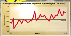
Department – better known as Metmalaysia now – average yearly temperatures between 1981 and 2020 have trended higher at a rate of 0.02ºc every year, which translates to 0.2ºc every decade.
Metmalaysia director-general Muhammad Helmi Abdullah says a rise in 1ºc could translate into a corresponding 7% increase in rainfall. This is according to the Sixth Assessment Report of the United Nations’ Intergovernmental Panel on Climate Change (released in August this year) and Malaysia’s Third National Communication to the panel.
“There has been an increase in the trend of average yearly temperatures although it’s not very drastic. But it can still have an impact on the weather in our country,” he says.
An increase in rainfall, says Muhammad Helmi, can be linked to more extreme thunderstorms which can lead to more frequent flash floods and landslides as well as water and land spouts, and hail.
He points to the 2006/2007 and 2014 massive floods in Johor and Kelantan respectively as examples of incidents of such extreme rainfalls.
Based on Metmalaysia’s observations, Muhammad Helmi says the highest average yearly temperature recorded in the country was in 2016 at 27.84ºc, which was 0.87ºc above normal.
This is followed by 1998, 2019 and 2020, he says. In fact, based on records between 1951 and last year as provided by Met-malaysia, nine of the 10 hottest years in the country have occurred in the past 20 years since 2000, except for 1998 (see graphics with Metmalaysia stats).
“The maximum highest temperature ever recorded in Malaysia was 40.1ºc in Chuping, Perlis, on April 9, 1998,” says Muhammad Helmi.
That year saw one of the most powerful El Ninos in recorded history, during which scientists say air temperature hiked up by 1.5ºc compared with the 0.25ºc usually associated with that global weather phenomenon.
“The rise in temperature can also cause heat waves and haze to become more extreme,” adds Muhammad Helmi.
Malaysians, he says, must realise that natural disasters from the effects of climate change are now unavoidable.
“But with knowledge, planning and early preparation, we can minimise the impact on mortality and property damage.
“Thus, members of the public must be prepared to face any possibility of natural disasters and always get the latest weather update by Metmalaysia in their areas.”
From paper charts to satellite images
With floods and hurricanes increasing, getting the latest weather updates out has become vital – lifesaving, even, when it gives uniformed personnel time to deploy in areas facing disaster. Metmalaysia has had to move with the times over the years to achieve this.
When Muhammad Helmi first joined the country’s Meteorological Department back in the 1980s, predicting the weather was about looking at the charts. Back then, the country didn’t have its own weather forecast models and needed to rely on those produced by other countries to try and predict whether it would be rain or shine the next day.
Muhammad Helmi remembers having to study details of the charts splayed out on tables or pinned up on boards.
“At that time, we had to plot the daily weather by hand,” reminisces the 57-year-old, who was posted to the then Subang International Airport, one of the more important places among his first few postings.
Thankfully, modern technology means predicting the daily weather doesn’t have to be that painstakingly arduous now.
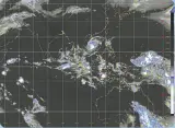
Malaysia now has its own weather forecast models and live satellite images can be displayed on gigantic electronic boards, while staff members work with computer screens and sophisticated seismographs.
When The Star visited Metmalaysia at its headquarters on Jalan Sultan, Petaling Jaya, recently, the images from Japan’s Himawari and China’s Feng Yun satellites were tracking a red dot – a sign of possible inclement weather – across different shades of the blues of the Indian Ocean.
First set up in 1958 as the Malaya Meteorological Service Office at the Simpang Airport in Kuala Lumpur – also known as the Sungai Besi Airbase – the office has undergone various changes as its role expanded.
Originally parked under the Transport Ministry as the Meteorological Service Malaysia in 1965 following Singapore’s departure from the federation, it was shifted to the Science, Technology and Environment Ministry in 1984.
Today, the department’s forecast office sits in an unassuming white building on a site that it has occupied since 1968, from where it keeps an eye out for everything from earthquakes and tsunamis to rain and wind, and even the ultraviolet index and heatwaves during the dry season.
Currently, Metmalaysia has a network of 247 automatic weather stations and 183 manual observation stations to detect data like rainfall, temperature, wind direction and speed, and atmospheric pressure. There are also additional stations to monitor acid deposition, the intensity of surface ultraviolet rays and background particulate matter, surface ozone, and aerosol concentrations.
Despite the advent of technology, though, work hasn’t necessarily become easier for the department, on which much of the country’s agricultural, plantation, aviation and even tourism sectors depend.
Winds of change
During our interview, Muhammad Helmi admits that with climate change, the department’s role has become more onerous and the forecasting work more challenging.
Typically, it’s harder to forecast the weather for a country with a tropical climate like Malaysia than, say, temperate countries like Japan and those in Europe which have four seasons. But it is even more challenging when climate change is wreaking havoc with established weather and wind patterns, much like what is happening with our monsoons.
“We can see a drastic change to our weather, like stronger thunderstorms and more occurrences of phenomena such as water spouts, land spouts and even hail, which used to be rare in the past.
“There’s also been an increase in the number of extreme weather events – an increase in both intensity and frequency,” says Muhammad Helmi.
“This has given rise to new challenges for Metmalaysia because knowledge of such events is currently quite limited.
“The main challenge for us is to determine when and where such high impact or extreme weather events will occur,” he explains.
He adds that the department is still studying the indicators or signs that may lead them to better forecast when and where such extreme weather events are likely to take place.
“An example of such an indicator would be wind patterns. We all know that between August and September this year, the southwest monsoon was weak, a situation known as a monsoon break.
“When a monsoon break happens, the wind blows from various directions and is rather weak, causing many thunderstorms to occur.
“The south-west monsoon was supposed to be a drier period for us. Instead, it was the opposite and we had many thunderstorms that even resulted in flash floods, including what happened in Yan recently,” he explains.
In mid-august, six people died in a landslide and over 1,000 more were affected by severe flash floods following heavy downpours in the district in Kedah.
The rains were so heavy that a water column came gushing down the side of Gunung Jerai while images and video clips of muddied roads, inundated cars, fallen trees and drenched residents went viral on social media.
Too darn hot
While scientists and forecasters agree that global warming is causing the evaporation of more moisture from land and sea, which translates into heavier rainfall, they are still scrambling to better predict extreme weather events.
To better spot indicators that can lead up to these extreme events in the future, Metmalaysia has embarked on a series of measures, including upgrading 60 existing manual observation stations to automatic as well as building new ones, and incorporating extra training for its staff.
Eight new radar stations are slated for completion next year – at Kuala Gula in Perak; Rompin, Temerloh and Cameron Highlands in Pahang; Marang in Terengganu; Kuala Krai in Kelantan; Sibu in Sarawak; and Tawau in Sabah.
“Hopefully, with these new radar stations we will be able to monitor and observe the weather for almost the entirety of Malaysia,” says Muhammad Helmi.
More importantly, the department is in the midst of developing a system capable of forecasting weather a few months in advance or giving projections even up to the year 2100.
This, says Muhammad Helmi, will allow national disaster agencies and water resources management to better plan and take early action in case of floods or droughts.
“The projection of up to 2100 based on the scaled down models of CMIP6 and shared socioeconomic pathways will enable better and more accurate simulations of how our country’s climate will look like in the future,” he says.
Coupled Model Intercomparison Project, or CIMP, which is now in phase six, is a framework which allows climate scientists around the world to collaborate and improve their knowledge on climate change. Coupled models are computer-based models of the Earth’s climate in which the atmosphere, oceans, land or ice are “coupled” together to interact in simulations.
Asked if Metmalaysia will consider recruiting the help of climate scientists to better understand and predict extreme events, Muhammad Helmi says it’s still best to ensure capacity building for its own staff.
“Upon acceptance into the service, our staff members have to undergo a year of training before being posted to a meteorological office for another year or even a few years.
“They will have to work at this meteorological office for at least a year so that they will know what the weather in that particular area is like during the different monsoons.
“They know the weather and climate of this country better because they have been in the field for so long,” he says, adding that the department has recently had one of its officers recognised as a subject matter expert under the civil service scheme.
“We have four more officers on the same career pathway,” he adds.
Moving on up
There are also plans to relocate Metmalaysia’s headquarters away from the narrow, busy street it now shares with the Road Transport Department and the Chemistry Department in PJ to a site in Labu near the KL International Airport by 2024 or 2025.
But even that comes with its own set of problems unique to the department, which operates 24/7 for 365 days every year.
The particular nature of forecasting, stresses Muhammad Helmi, means that Metmalaysia can’t afford to shut down its operations in the country for even one minute.
“Earthquakes and weather changes happen all the time. Much of the department’s operations must already be set up at the new location for, say, a month before we can actually move to the new site.
“We are currently holding workshops to determine our needs at the new building,” he says.
Meanwhile, rain or shine, or hail and hurricanes for that matter, Malaysians must keep up with Metmalaysia’s daily forecasts now that unpredictable weather is the norm.
- The Star Malaysia21 Dec 2021by SIM LEOI LEOI lifestyle@thestar.com.my
Forecasting the weather amid climate change
— Photos: IZZRAFIQ alias/the star
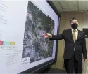
muhammad Helmi explaining a satellite image at metmalaysia headquarters.
The maximum highest temperature ever recorded in Malaysia was 40.1ºc in Chuping, Perlis, on April 9, 1998,” says Muhammad Helmi
That year saw one of the most powerful El Ninos in recorded history, during which scientists say air temperature hiked up by 1.5ºc compared with the 0.25ºc usually associated with that global weather phenomenon.
“The rise in temperature can also cause heat waves and haze to become more extreme,” adds Muhammad Helmi.
Malaysians, he says, must realise that natural disasters from the effects of climate change are now unavoidable.
“But with knowledge, planning and early preparation, we can minimise the impact on mortality and property damage.
“Thus, members of the public must be prepared to face any possibility of natural disasters and always get the latest weather update by Metmalaysia in their areas.”
From paper charts to satellite images
With floods and hurricanes increasing, getting the latest weather updates out has become vital – lifesaving, even, when it gives uniformed personnel time to deploy in areas facing disaster. Metmalaysia has had to move with the times over the years to achieve this.
When Muhammad Helmi first joined the country’s Meteorological Department back in the 1980s, predicting the weather was about looking at the charts. Back then, the country didn’t have its own weather forecast models and needed to rely on those produced by other countries to try and predict whether it would be rain or shine the next day.
Muhammad Helmi remembers having to study details of the charts splayed out on tables or pinned up on boards.
“At that time, we had to plot the daily weather by hand,” reminisces the 57-year-old, who was posted to the then Subang International Airport, one of the more important places among his first few postings.
Thankfully, modern technology means predicting the daily weather doesn’t have to be that painstakingly arduous now.
Malaysia now has its own weather forecast models and live satellite images can be displayed on gigantic electronic boards, while staff members work with computer screens and sophisticated seismographs.
When The Star visited Metmalaysia at its headquarters on Jalan Sultan, Petaling Jaya, recently, the images from Japan’s Himawari and China’s Feng Yun satellites were tracking a red dot – a sign of possible inclement weather – across different shades of the blues of the Indian Ocean.
First set up in 1958 as the Malaya Meteorological Service Office at the Simpang Airport in Kuala Lumpur – also known as the Sungai Besi Airbase – the office has undergone various changes as its role expanded.
Originally parked under the Transport Ministry as the Meteorological Service Malaysia in 1965 following Singapore’s departure from the federation, it was shifted to the Science, Technology and Environment Ministry in 1984.
Today, the department’s forecast office sits in an unassuming white building on a site that it has occupied since 1968, from where it keeps an eye out for everything from earthquakes and tsunamis to rain and wind, and even the ultraviolet index and heatwaves during the dry season.
Currently, Metmalaysia has a network of 247 automatic weather stations and 183 manual observation stations to detect data like rainfall, temperature, wind direction and speed, and atmospheric pressure. There are also additional stations to monitor acid deposition, the intensity of surface ultraviolet rays and background particulate matter, surface ozone, and aerosol concentrations.
Despite the advent of technology, though, work hasn’t necessarily become easier for the department, on which much of the country’s agricultural, plantation, aviation and even tourism sectors depend.
Winds of change
During our interview, Muhammad Helmi admits that with climate change, the department’s role has become more onerous and the forecasting work more challenging.
Typically, it’s harder to forecast the weather for a country with a tropical climate like Malaysia than, say, temperate countries like Japan and those in Europe which have four seasons. But it is even more challenging when climate change is wreaking havoc with established weather and wind patterns, much like what is happening with our monsoons.
“We can see a drastic change to our weather, like stronger thunderstorms and more occurrences of phenomena such as water spouts, land spouts and even hail, which used to be rare in the past.
“There’s also been an increase in the number of extreme weather events – an increase in both intensity and frequency,” says Muhammad Helmi.
“This has given rise to new challenges for Metmalaysia because knowledge of such events is currently quite limited.
“The main challenge for us is to determine when and where such high impact or extreme weather events will occur,” he explains.
He adds that the department is still studying the indicators or signs that may lead them to better forecast when and where such extreme weather events are likely to take place.
“An example of such an indicator would be wind patterns. We all know that between August and September this year, the southwest monsoon was weak, a situation known as a monsoon break.
“When a monsoon break happens, the wind blows from various directions and is rather weak, causing many thunderstorms to occur.
“The south-west monsoon was supposed to be a drier period for us. Instead, it was the opposite and we had many thunderstorms that even resulted in flash floods, including what happened in Yan recently,” he explains.
In mid-august, six people died in a landslide and over 1,000 more were affected by severe flash floods following heavy downpours in the district in Kedah.
The rains were so heavy that a water column came gushing down the side of Gunung Jerai while images and video clips of muddied roads, inundated cars, fallen trees and drenched residents went viral on social media.
Too darn hot
While scientists and forecasters agree that global warming is causing the evaporation of more moisture from land and sea, which translates into heavier rainfall, they are still scrambling to better predict extreme weather events.
To better spot indicators that can lead up to these extreme events in the future, Metmalaysia has embarked on a series of measures, including upgrading 60 existing manual observation stations to automatic as well as building new See page 3
How extreme weather may lead to food shortages
IN a world with an increasing human population, climate change may have a serious impact on our ability to grow enough food.
— Bloomberg
abundance at a fresh fruit stall in a London wholesale market – but how long will it last as the climate crisis continues wreaking havoc on global weather and threatening food production?
Research from as far back as 2007 found that around 30% of year-to-year fluctuations in tonnes of crops grown per hectare were due to changes in the climate. It is remarkable that under these circumstances the global agricultural system has managed to remain fairly robust, and that major food shortages have been rare.
On the other hand, food prices in recent decades have become increasingly volatile. While there are many influences on food prices – including crop yield, weather variations, international trade, speculation in food commodity markets, and land management practices – mostly open trading systems have allowed food shortages in some places to be offset by surpluses and increased production elsewhere.
However, now that the world seems to be moving toward more trade barriers at a time when climate change is intensifying, these stabilising effects may start to fail. Prices could
Without fertiliser, us farm yields would have fallen drastically as soil quality has been decreasing. However, poorer parts of the world do not have the resources to compensate for barren land with fertilisers in the same way. —AFP rise sharply, putting pressure on poor countries and on the budgets of poor people in rich countries.
While crop growth per hectare has increased considerably over the last 50 years, recently the rate of this growth has slowed compared with previous decades. Recent research suggests that up to 30% of the expected increase in growth of European crops has been cancelled out by adverse weather.
But it is worrying that the most pronounced changes tend to be in countries such as those in sub-saharan Africa, including South Africa, that are at high risk of climate impacts on food availability and affordability.
This is particularly clear in the case of barley, maize, millet, pulses, rice and wheat. It seems that the countries most at risk of food shortages are also worst affected by rising temperatures. This seems to bear out the finding from the world’s premier climate science advisers, the Intergovernmental Panel on Climate Change (IPCC), that the higher average global temperatures and more extreme weather events associated with climate change will reduce the reliability of food production. The latest IPCC report, released in August, also supports this conclusion.
Another change noted by the IPCC is how rising heat and rainfall associated with climate change is increasingly degrading land, making soil less productive. This is due to the loss of soil nutrients and organic matter and has negative effects on crop yields.
In addition, accelerating rises in sea levels will compound these negative impacts by increasing saltwater intrusions and permanently flooding crop land.
Recent modelling of soil loss in wheat and maize fields shows large variations between tropical climate regions and regions with a large proportion of flat and dry land, with losses ranging from less than 1 tonne per hectare in central Asia to 100 tonnes per hectare in South-east Asia.
The strong impact of climate and topography on simulated water erosion is clearly shown in the five largest wheat and maize producing countries: in Brazil, China and India, where a large proportion of cropland is in tropical areas, water erosion is relatively high, while in Russia and the United States annual median values are much lower.
However, historically poor management of lands in Europe and the United States has been largely remedied through the increased use of chemical fertilisers and irrigation, which have been able to offset a massive amount of soil degradation.
For example, one study has shown that, without fertiliser, US yields of corn over the past 100 years would have fallen from around seven to a little over one tonne per hectare due to soil quality decreasing. However, fertiliser has enabled yields to be broadly maintained, although at an annual cost to farmers of over Us$0.5bil (Rm2.1bil).
These results have worrying implications for poorer parts of the world where soil quality is decreasing, but which do not have the resources to compensate for this with fertilisers. And the results become more worrying still if this is exacerbated by climate change.
Many aspects of land management for food production have changed in recent decades, including growing different crops, or the same crops in different places, in response to increased temperatures. The overall result of these changes has been greatly increased food yields in many parts of the world, and land managers may be expected to adapt their strategies for changes in the climate.
But if climate change results in simultaneous failure of major crops such as wheat, maize and soybeans in two or more major breadbasket regions (the areas of the world that produce most food), then the risks of price rises making food too expensive in poorer parts of the world could become acute. – The Conversation
- By PAUL EKINS Paul Ekins is professor of Resources and Environmental Policy at University College London. This article is republished from The Conversation under a Creative Commons license.
It's not a one-off occurrence, warns climatologist | The Star

Related posts:
Climate concern: The sun rising behind the
chimneys of a thermal power station. A recent International Monetary
Fund study points out th...
The Meteorological Department has been providing information and warnings since Dec 11 about the continuous rainfall that caused the massiv...


